Modelling ecological health in NSW rivers
Healthy rivers are vital to many of our native ecosystems and species. Low or no flow in a river can raise salinity, contribute to algal blooms, and affect estuary and marine health. It also affects the long-term viability of plant communities such as river red gum forests and wetlands. This is bad news for native animals, birds, fish and insects.

Understanding the potential impact of our options
When we developed NSW’s regional water strategies, we assessed the ecological impacts of a selected number of management options in detail by modelling them under different possible future climates. The future climate scenarios we modelled were based on a 10,000-year natural climate variability dataset built using palaeoecological data, and NARCliM’s worst-case dry climate.
You can learn more about the climate scenarios from our detailed hydrologic analysis report.
Assessing the Clarence River to Bellingen pipeline
One of the options we assessed for improving water security on the North Coast was the Clarence River to Bellingen pipeline.
To assess this option, we created ecological effect ratings based on how much the change would affect the river in a negative or positive way. We then identified key ecological features of the river’s flow.
We assessed the pipeline’s ecological impacts on key ecological features at various points along the river under a base case scenario that reflected current river system conditions; a climate like the one indicated by the 10,000-year daily natural variability dataset; and the more extreme future dry-climate scenario. This allowed us to ‘pressure test’ the pipeline option.
We looked at metrics such as how many times the river stopped flowing, and in how many years; how long it stopped flowing each time; how much water flowed through the river when it was very low or low; how often the river experienced flows each year, and how much.
You can see the full list of metrics in our detailed assessment report.
None of pipeline’s potential impacts were found to be significant, with all having less than a 3% impact. For example, the number of years the Orara River would cease to flow (once or more) at Glenreagh increased by only about 1% across a 130-year period.
However, while models allow us to assess options and identify the most attractive, they have limits. For example, because our modelling of the pipeline’s effects only provides information about average impacts across a long period of time, there will probably be times when the impact of the pipeline will be much greater than 3%--so we know that, if the pipeline becomes a priority, we must explore how low flow would affect the significant Orara River fish community in more depth. We also know that the Orara River’s riparian zone is in poor condition and the reduced oxygen and increased temperature that come with lower flows would further reduce water quality.

Healthy rivers, healthy ecosystems
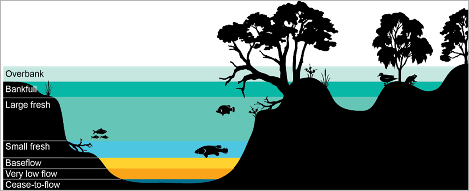
Native fish need different kinds of river flow at different times in their life to survive and thrive. Young fish need slow-flowing backwaters and floodplains but, as they grow, they return to the main channel where riverbank vegetation and base flows are essential for keeping the water cool and in supporting their food supply.
Riverbank vegetation needs bigger flows, like freshes, overbank and floodplain flows, to be healthy. These bigger flows allow fish to move along and across the rivers so they can reproduce and, by capturing debris off river benches, riverbanks and floodplains, are the main energy source for river food webs. They also top up soil and groundwater stores, which can hold water and support vegetation for months afterward.
Waterbirds, too, need healthy billabongs, riverbanks, woodlands and grasslands—and they need the river to overflow into wetlands or floodplains so they can feed and breed.

NSW coastal river systems are home to many at-risk species like the purple-spotted gudgeon, mangrove honeyeater, Oxleyan pygmy perch and many others. You can learn more about these and other species from the Saving our Species program site.
Learn more
We have shared the North Coast ecological assessment and South Coast ecological assessment on the DPE website. You can also find out more about how we used paleo data to model 10,000 years of past Australian climate there.
The full 10,000-year climate dataset and supporting technical documentation are available on SEED.
Linked Datasets
-
The fundamental input data of work undertaken by Water Modelling Team is climate data in the form of daily rainfall and potential evapotranspiration. This data is input to water mo ...
- SEED Web Map
- ARCGIS REST SERVICE